Hidden Figures| Light the Path
Team Updates
We want to thank Facundo Magliaro, without him and his moral, his encouragement and his gigantic charisma we wouldn't got this far.
Introduction
Our world is more interconnected than ever before—by global travel and trade, by technology, and even by our viruses. Human health is connected to animal and environmental health. As our population grows, we interact with animals and the environment in new ways that can cause disease outbreaks and epidemics.
When people move into or change an environment, pathogens can “jump” from wildlife to humans and cause disease outbreaks that spread internationally. Tracking down and responding to outbreaks requires coordinated work from people in many professions.
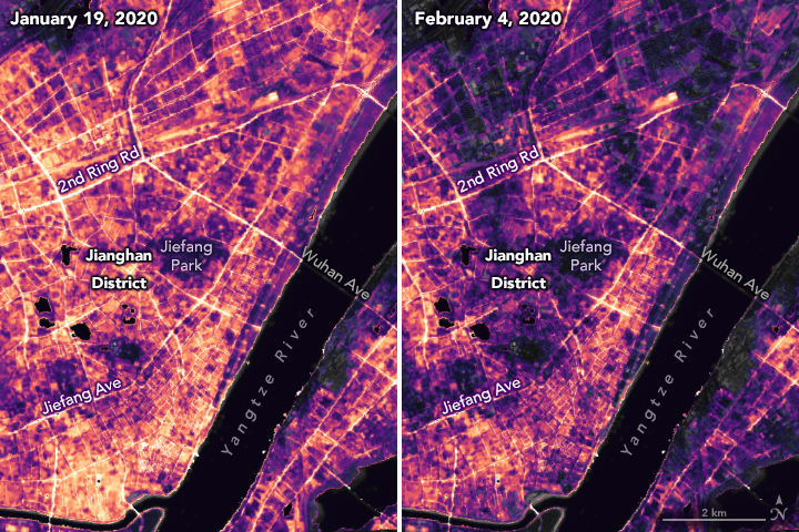
In late 2019, an unknown virus causing pneumonia-like illness emerged in Wuhan, China, and spread rapidly and globally. The virus was soon identified and genetically sequenced: it was a new (or "novel") type of coronavirus, which was named SARS-CoV-2 [18].
Past epidemics, such as the yellow fever in Buenos Aires and the black plague in Europe, taught us that diseases can have profound demographic consequences. It is common that people, due to public beliefs associated with the disease and how it is transmitted, migrate from a highly populated area or an affected region, to less populated places, where the spread should be less probable. However, it is also possible to bring the disease to these areas, where they could set up a new outbreak.
About the Project
The project consists in an app called “Global Remote Sensing” whose principal function is to provide governments with information in an organized and clear way in order to improve the decision-making in a pandemic. It would allow, among other things, to predict future outbreaks in the short term and to warn regions about the danger it poses.
Infectious diseases
Outbreaks
An outbreak is a classification used in epidemiology to name the sudden apparition of a disease due to an infection in a specific place and in a determined moment. A clear example of this situation is when a case of food poisoning triggers new cases for two or three days. Other examples are the outbreaks of meningitis and measles which could extend for two or three months.
Epidemics
Meanwhile, an epidemic occurs when a disease is spread actively due to an out of control outbreak and it lasts in time. In this way, it increases the number of cases in a particular geographical area.
Pandemics
In order to declare pandemic status, there are two criteria to consider: the outbreak must affect more than one continent and the cases at each country must be due to community spread in addition to the imported cases. “While the cases were imported and the epidemic outbreak was located in China, the situation [of COVID-19] was qualified as epidemic, but in the moment it jumps to other countries and start community spread in more than one continent, it becomes a pandemic”, explained Ángel Gil, professor of Preventive Medicine and Public Health at the University King Juan Carlos.
Satellites and Teledetection
Brief introduction into Teledetection[13]
Teledetection is a way to obtain information from objects by taking and analyzing data with instruments which are not in direct contact with the object in question.
When the object of study is the planet itself, the scientists obtain all kinds of information, through teledetection, about the atmosphere and/or the surface. This is made possible by planes and satellites equipped with the necessary measurement tools.
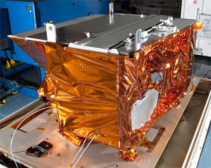
Visible Infrared Imaging Radiometer Suite[11][23] (VIIRS)
The VIIRS is a sensor made by the Raytheon Company on board the Suomi-National Polar-orbiting Partnership (S-NPP), the Day/Night Band (DNB) sensors of the VIIRS provide daily measurements of nocturnal visible and near-infrared light that are suitable for earth system science and applications studies. Since the launch of the S-NPP satellite in 2011, multiple studies have VIIRS DNB as primary data source.
Some of those studies have employed statistical analyses and correlation discovery methods to confirm empirical relationships with a wide range of human-linked patterns and processes. Including socioeconomic variables, as well as changes driven by urban built-up expansion, and energy use. Therefore, the VIIRS DNB data is the principal source for the analysis of these subjects in the context of the project.
Development
Satellites and demographics
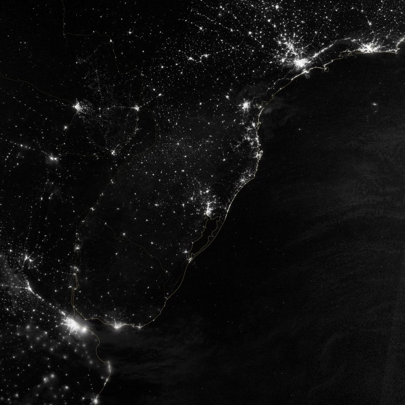
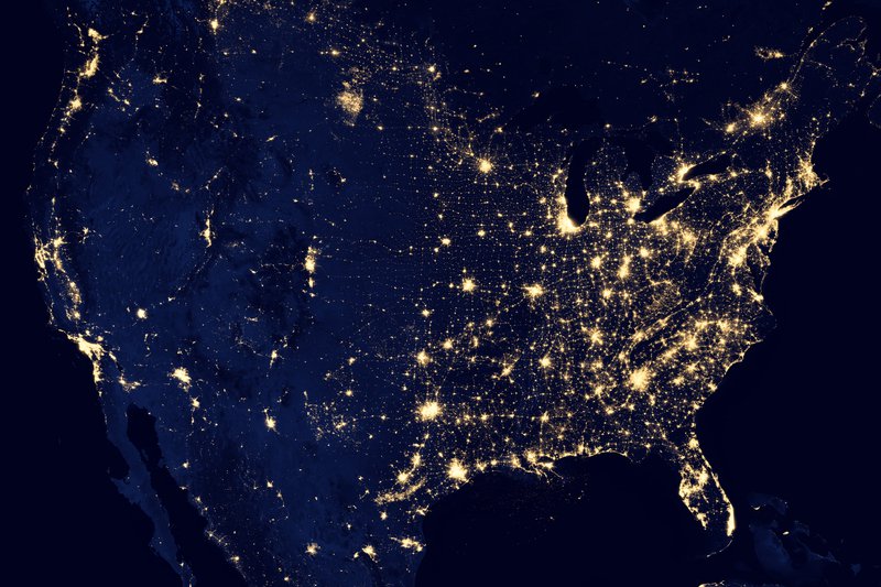
Firstly, by means of teledetection, images of the night lights of a selected region and its surroundings can be obtained. Periodic gathering of these images during a certain lapse of time (weeks, months) can be interpreted using demographic image analysis methods.[15][19]For instance, the Night Light Development Index (NLDI) can be used as a parameter to measure population density. Thereby, it is possible to carry out a satellite census, and then describe the migratory movements that have been motivated by the pandemic.
Epidemiological modelling
Using computational epidemiology, it is possible to utilize the data provided by local hospitals and health centers to produce a model of the infection. The number of COVID-19 cases, the recovery rates, mortality and hospital capacity are variables that play a fundamental role in describing the pandemic evolution through time. Government information such as quarantine regulations, and public health expenditure are also of great importance and can be incorporated into the model, thus making it even more reliable. [5][6]
Information superposition
The vision of the group is to use already existing data in the most efficient way possible, and it is with this idea in mind that the core of the project is conceived: by combining both the demographic and epidemiological data discussed above, a global description of the pandemic is achieved. This comprehensive model thus shows the correlations between human activity (work, housing, migration, public transport) and the COVID-19 spread. All this information is presented in an interactive map, to which government and health authorities will have access, allowing them to make informed decisions.
Furthermore, an accurate description of the regional situation (through reliable information) and a clever selection of the computational models implemented (i.e. machine learning) [23] offer the tool of extrapolation. This means that the model can make predictions on how the virus will spread in the near future: where will the next outbreak occur, how many infected will there be, and how many resources will be necessary. Government officials can even run state-of-the-art simulations to evaluate the outcome of different pandemic-response plans, and subsequently decide which of these plans is the most appropriate.
Further developments - Public alternative of the Project
Future epidemics
The analysis made for the COVID-19 situation can be studied and replicated for outbreaks and epidemics that have not yet occured, thus preventing their spread and reducing the impact. It would take data of live outbreaks from reliable sources [21][22] and predict how they will evolve in the short term. By adding the data of how they evolve in the end, it would become an increasingly more precise tool of prediction.[23]
Interactive App
The Project could be redesigned into an app, with similar qualities, focused on the awareness and understanding, of the actual situation, of regular people.
Test
It could be possible to introduce a simple online test in the app for regular people which would analyze the efficiency of the lights used in their houses. It would allow to improve the estimation between the light detected by satellites and the light used per person. At the same time, it would tell the user feedback about light pollution and how much they are contributing to it, in order to make them aware of the gravity of it [7] [8] [9].
Bibliography
[1] NASA, Black Marble.https://blackmarble.gsfc.nasa.gov/
[2] NASA, VIIRS Land Product.https://viirsland.gsfc.nasa.gov/Products/NASA/BlackMarble.html
[3] NASA, Nighttime images. https://earthobservatory.nasa.gov/images/146481/nighttime-images-capture-change-in-china
[4] NASA, SEDAC Global COVID-19 Viewer.https://sedac.ciesin.columbia.edu/mapping/popest/covid-19/
[5] Kevin Simler, Going Critical.https://meltingasphalt.com/interactive/going-critical/
[6] Kevin Simler, Outbreak.https://www.meltingasphalt.com/interactive/outbreak/
[7] Jurij Stare, Light Pollution Map.https://www.lightpollutionmap.info/
[8] Rebecca Morelle Science Correspondent, BBC News, Light pollution 'affects 80% of global population' .https://www.bbc.com/news/science-environment-36492596
[9] F. Falchi, et al, The new world atlas of artificial night sky brightness.https://advances.sciencemag.org/content/2/6/e1600377
[10] NASA, Giovanni.https://giovanni.gsfc.nasa.gov/giovanni/
[11] Miguel O. Román, et al, NASA's Black Marble nighttime lights product suite.https://www.sciencedirect.com/science/article/pii/S003442571830110X
[12] JAXA, G-Portal.https://gportal.jaxa.jp/gpr/search?tab=0
[13] ESA, ¿Qué es la teledetección?.http://www.esa.int/SPECIALS/Eduspace_ES/SEMO1U3FEXF_0.html
[14] NASA, Even from Space, Holidays Shine Brightly.https://earthobservatory.nasa.gov/images/84897/even-from-space-holidays-shine-brightly
[15] Noam Levin, High spatial resolution night-time light images for demographic and socio-economic studies.https://www.researchgate.net/publication/236016293_High_spatial_resolution_night-time_light_images_for_demographic_and_socio-economic_studies
[16] Demetris Stathakis, Pavlos Baltas, Seasonal population estimates based on night-time lights.https://www.sciencedirect.com/science/article/pii/S0198971517303113
[17] Qing Liu, Paul C. Sutton, Christopher D. Elvidge, Relationships between Nighttime Imagery and Population Density for Hong Kong. https://www.researchgate.net/publication/272778914_Relationships_between_Nighttime_Imagery_and_Population_Density_for_Hong_Kong
[18] Museum Smithsonian, Outbreak: Epidemics in a Connected World. Digital Exhibit. https://naturalhistory.si.edu/exhibits/outbreak/digital-exhibit
[19] Kinga Ivan, Iulian-Horia Holobâcă, József Benedek and Ibolya Török, Potential of Night-Time Lights to Measure Regional Inequality.
[20] Madhav Marathe and Naren Ramakrishnan,Recent Advances in Computational Epidemiology https://www.ncbi.nlm.nih.gov/pmc/articles/PMC4258713/
[21] International Society for Infectious Diseases,ProMED-mail alerts on HealthMap, https://promedmail.org/
[22] Computational Epidemiology Lab,HealthMaphttps://healthmap.org/
[23] Timothy L. Wiemken and Robert R. Kelley, Machine Learning in Epidemiology and Health Outcomes Research, https://www.annualreviews.org/doi/full/10.1146/annurev-publhealth-040119-094437
[23] STAR JPSS, Visible Infrared Imaging Radiometer Suite (VIIRS), https://www.star.nesdis.noaa.gov/jpss/VIIRS.php