Ghostbusters 2.0| Quiet Planet
Team Updates
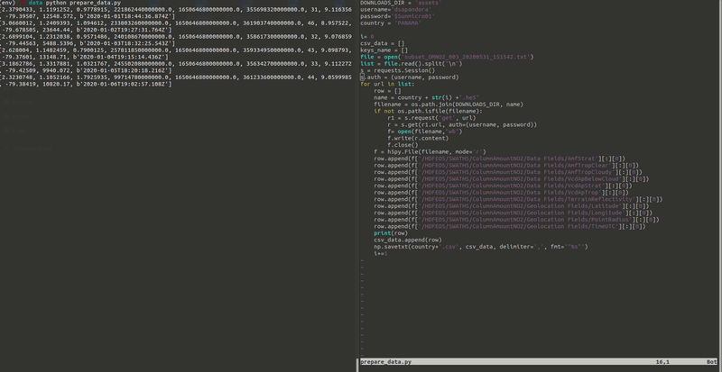
| importh5py | |
| importos | |
| importrequests | |
| importnumpyasnp | |
| DOWNLOADS_DIR=<folder> | |
| username=<user> | |
| password=<Password> | |
| country=<filename> | |
| i=0 | |
| csv_data= [] | |
| keys_name= [] | |
| file=open(<file_with_datasets_urls>) | |
| list=file.read().split("\n") | |
| s=requests.Session() | |
| s.auth= (username, password) | |
| forurlinlist: | |
| row= [] | |
| name=country+str(i) +".he5" | |
| filename=os.path.join(DOWNLOADS_DIR, name) | |
| ifnotos.path.isfile(filename): | |
| r1=s.request('get', url) | |
| r=s.get(r1.url, auth=(username, password)) | |
| f=open(filename,"wb") | |
| f.write(r.content) | |
| f.close() | |
| f=h5py.File(filename, mode='r') | |
| # this can be changes using f['/HDFEOS/SWATHS/ColumnAmountNO2/Data Fields/').keys() then travel accross all the keys | |
| row.append(f['/HDFEOS/SWATHS/ColumnAmountNO2/Data Fields/AmfStrat'][:][0]) | |
| row.append(f['/HDFEOS/SWATHS/ColumnAmountNO2/Data Fields/AmfTropClear'][:][0]) | |
| row.append(f['/HDFEOS/SWATHS/ColumnAmountNO2/Data Fields/AmfTropCloudy'][:][0]) | |
| row.append(f['/HDFEOS/SWATHS/ColumnAmountNO2/Data Fields/VcdApBelowCloud'][:][0]) | |
| row.append(f['/HDFEOS/SWATHS/ColumnAmountNO2/Data Fields/VcdApStrat'][:][0]) | |
| row.append(f['/HDFEOS/SWATHS/ColumnAmountNO2/Data Fields/VcdApTrop'][:][0]) | |
| row.append(f['/HDFEOS/SWATHS/ColumnAmountNO2/Data Fields/TerrainReflectivity'][:][0]) | |
| row.append(f['/HDFEOS/SWATHS/ColumnAmountNO2/Geolocation Fields/Latitude'][:][0]) | |
| row.append(f['/HDFEOS/SWATHS/ColumnAmountNO2/Geolocation Fields/Longitude'][:][0]) | |
| row.append(f['/HDFEOS/SWATHS/ColumnAmountNO2/Geolocation Fields/PointRadius'][:][0]) | |
| row.append(f['/HDFEOS/SWATHS/ColumnAmountNO2/Geolocation Fields/TimeUTC'][:][0]) | |
| print(row) | |
| csv_data.append(row) | |
| i+=1 | |
| np.savetxt(country+'.csv', csv_data, delimiter=',', fmt='"%s"') |


The backend structure has been deployed
So right now, we start the app development
Nickolay A. Krotkov, Lok N. Lamsal, Sergey V. Marchenko, Edward A. Celarier, Eric J.Bucsela, William H. Swartz, Joanna Joiner and the OMI core team (2019), OMI/Aura NO2 Cloud-Screened Total and Tropospheric Column L3 Global Gridded 0.25 degree x 0.25 degree V3, NASA Goddard Space Flight Center, Goddard Earth Sciences Data and Information Services Center (GES DISC), Accessed: [Data Access Date], 10.5067/Aura/OMI/DATA3007
Giovanni Parameter Definitions: Nitrogen Dioxide
Nitrogen Dioxide
Definition
The number of molecules of NO2 in an atmospheric column (from the Earth's surface to the top of the atmosphere) above a square centimeter of the surface. In L2G Giovanni, NO2 data is provided only for near clear sky conditions (i.e only those NO2 retrievals are used in the analysis for which Cloud radiance fraction is less than 30%).
Applications
Pollution
Urban influence
Wildfires
Energy
Empirical evidence about microclimate UHI variation in districts with different meteorological and environmental settings has enriched the comparative understanding of UHI in urban communities.
The findings show that microclimate variation does exist within an urban area as a result of the interplay between urban morphology and local meteorological factors. Although temporal behavior of daily UHI was found to follow the theoretical pattern, spatial variability of microclimate involved complex interactions and very much location dependent.
Wong, P. P. Y., Lai, P. C., Low, C. T., Chen, S., & Hart, M. (2016). The impact of environmental and human factors on urban heat and microclimate variability. Building and Environment, 95, 199-208.
In The impact of environmental and human factors on urban heat and microclimate variability, This study established the existence and extent of microclimate variation of UHI within urban communities of different environmental configuration and functional uses.
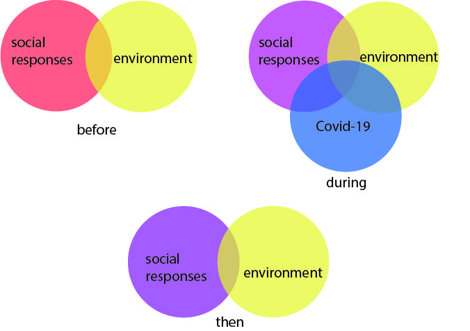
To statt the team objective is to use space-based data to document the local to global environmental changes caused by COVID-19 and the associated societal responses.